
 mobile
Category: crazy
08/22/06 10:31 - ID#21078
Pan Am Expo Mapping
If there were any doubts as to my lack of sanity, I now lay them to rest with this wonderful example of how my warped mind works.
Two days ago, I was up at an hour I really shouldn't have been up at watching a public access TV channel documentary on the history of Buffalo. I found it quite fascinating, as I tend to find a lot of Buffalo history.
They got to the Pan American Expo of 1901, and that really picqued my interest. I knew that there was some massive world's fair type thing 100 years ago in Buffalo, but I never knew quite where it was. I also knew that President McKinley was assinated at the Temple of Music, a building that was considered one of the crown jewels of the expo. Having finished watching the documentary, I now not only wanted to find where the expo took place, but I especially wanted to find the location where the Temple of Music stood. I knew that if I could find the marker that marked the area where McKinley was assasinated, I'd find the former location of the Temple of Music.
After some searching, I managed to score a really decent map of the expo.
I also found out that the expo happened in the area north of Delaware Park. So I now knew the location of the Temple Of Music in relation to the rest of the expo (from looking at the map), and I also knew the location of the expo in relation to the city as it is today, but I still didn't know where the TOM (I'll abbreviate it now) stood in relation to the streets of today, and that piece of knowledge I was searching for would lead me to the place I needed to travel to visit the former site of the TOM.
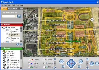
While I had a map of the modern city (courtesy of Google Earth) and a map of the expo from a hundred years ago, it was an enormously large pain in the ass trying to mentally navigate between the two maps, each in its own separate window on my computer. "What I really need", I said to myself, "is a way of making one of the windows transparent, or some way of overlaying the two images on top of one another." I was getting really frustrated, because I didn't own any software that could do this and I wasn't in the mood to write a one-off program on my mac that would let me do this that I'd probably never use again. Then, out of the blue, it hit me: Google maps lets you overlay transparent images! I could use that.
At this point, I had already found out through other sources that the McKinley monument was on east Fordham Dr. But since I had already done all this work, I might as well confirm the results for myself. So I pursued this perverse idea of laying the image of expo map over the current satellite imagery in Google Earth. Using the Buffalo historical society building (the only building remaining from the expo), the bodies of water near Delaware part, and the train tracks cutting across Elmwood Delaware all as reference points to help me accurately place the overlay over the current city, I was able to confirm that east Fordham Dr. was indeed the site of the TOM where McKinley was shot.
Here is a screenshot of the overlay of the 1901 Expo map over satellite imagery of the city as it currently is, for the people who may not have Google Earth installed on their machines.
The Google Earth file can also be found on Gather, tracking number is 0537094001156306145
The coolest thing to do with Google Earth and my map file is to adjust the transparency of the overlay, which takes you from past to present and vice-versa. You see the most striking similarities/differences around the ponds of Delaware park; adjust the transparency of the layer from opaque to transparent and you start seeing interesting things like part of the pond being filled in, while some stuff like trails and treelines have remained virtually the same for a century. It's also kind of interesting how some features of the exposition grounds (e.g. paths and roads) sometimes perfectly fit over the outline of today's buildings, especially the long and narrow ones. Very curious, indeed.
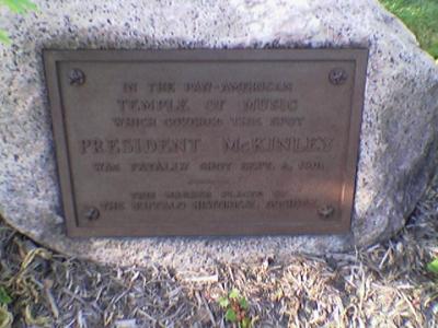
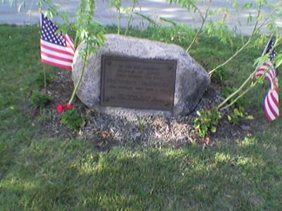
Anyhow, the next day after I watched the documentary and after an arduous day at work that I needed to unwind from, I was able to go to the former site of the TOM and snap a few photos. I'd have to say that of all the monuments to presidents I've ever seen, the McKinley boulder is the most low-key; it's basically a rock with a plaque and two flags in your run of the mill residential neighborhood. Which in a way is kind of cool, as marble is sort of cliche and it's probably neighborhood people (as opposed to government employees) maintaining the monument.
In the coming months, I'll try to think up other unusual expo things I can do with this map.
Two days ago, I was up at an hour I really shouldn't have been up at watching a public access TV channel documentary on the history of Buffalo. I found it quite fascinating, as I tend to find a lot of Buffalo history.
They got to the Pan American Expo of 1901, and that really picqued my interest. I knew that there was some massive world's fair type thing 100 years ago in Buffalo, but I never knew quite where it was. I also knew that President McKinley was assinated at the Temple of Music, a building that was considered one of the crown jewels of the expo. Having finished watching the documentary, I now not only wanted to find where the expo took place, but I especially wanted to find the location where the Temple of Music stood. I knew that if I could find the marker that marked the area where McKinley was assasinated, I'd find the former location of the Temple of Music.
After some searching, I managed to score a really decent map of the expo.
I also found out that the expo happened in the area north of Delaware Park. So I now knew the location of the Temple Of Music in relation to the rest of the expo (from looking at the map), and I also knew the location of the expo in relation to the city as it is today, but I still didn't know where the TOM (I'll abbreviate it now) stood in relation to the streets of today, and that piece of knowledge I was searching for would lead me to the place I needed to travel to visit the former site of the TOM.
While I had a map of the modern city (courtesy of Google Earth) and a map of the expo from a hundred years ago, it was an enormously large pain in the ass trying to mentally navigate between the two maps, each in its own separate window on my computer. "What I really need", I said to myself, "is a way of making one of the windows transparent, or some way of overlaying the two images on top of one another." I was getting really frustrated, because I didn't own any software that could do this and I wasn't in the mood to write a one-off program on my mac that would let me do this that I'd probably never use again. Then, out of the blue, it hit me: Google maps lets you overlay transparent images! I could use that.
At this point, I had already found out through other sources that the McKinley monument was on east Fordham Dr. But since I had already done all this work, I might as well confirm the results for myself. So I pursued this perverse idea of laying the image of expo map over the current satellite imagery in Google Earth. Using the Buffalo historical society building (the only building remaining from the expo), the bodies of water near Delaware part, and the train tracks cutting across Elmwood Delaware all as reference points to help me accurately place the overlay over the current city, I was able to confirm that east Fordham Dr. was indeed the site of the TOM where McKinley was shot.
Here is a screenshot of the overlay of the 1901 Expo map over satellite imagery of the city as it currently is, for the people who may not have Google Earth installed on their machines.
The Google Earth file can also be found on Gather, tracking number is 0537094001156306145
The coolest thing to do with Google Earth and my map file is to adjust the transparency of the overlay, which takes you from past to present and vice-versa. You see the most striking similarities/differences around the ponds of Delaware park; adjust the transparency of the layer from opaque to transparent and you start seeing interesting things like part of the pond being filled in, while some stuff like trails and treelines have remained virtually the same for a century. It's also kind of interesting how some features of the exposition grounds (e.g. paths and roads) sometimes perfectly fit over the outline of today's buildings, especially the long and narrow ones. Very curious, indeed.
Anyhow, the next day after I watched the documentary and after an arduous day at work that I needed to unwind from, I was able to go to the former site of the TOM and snap a few photos. I'd have to say that of all the monuments to presidents I've ever seen, the McKinley boulder is the most low-key; it's basically a rock with a plaque and two flags in your run of the mill residential neighborhood. Which in a way is kind of cool, as marble is sort of cliche and it's probably neighborhood people (as opposed to government employees) maintaining the monument.
In the coming months, I'll try to think up other unusual expo things I can do with this map.
Permalink: Pan_Am_Expo_Mapping.html
Words: 874
Author Info

Date Cloud
Category Cloud
More Entries
After This
My Fav Posts
- Click the heart at the bottom of anyone's blog entry to add it here ;(
 Lovey at Niagara Falls
Pay attention to the New York State Building, the only permanent structure built for the Expo. Now it's the Historical Society.
- Z