Paul's Journal

My Podcast Link
04/20/2005 03:59 #31861
More mappingTerry and I drove down ferry from east to west at like 2am in effort to test the mapping project. We drove from the como mall to the home and it mapped the whole trip perfectly. Sorry to hear you were ill (e:southernyankee).

04/19/2005 15:30 #31860
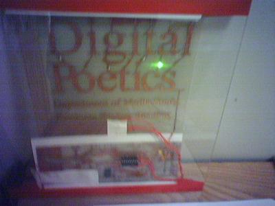
Poetry FlyerHere is the light up sign that jesse made for our poetry reading. I wish I could get a better pic of it. It lights up. I will get a pic of it tommorow.

04/19/2005 04:55 #31859
Quoted at publish.comWhat a weird day!
I was really most concerned about a single toolkit approach to graphic design.
Paul Visco, a professor in the digital media arts program at Canisius College in Buffalo, N.Y., said he worries about competition, pricing and the future of graphic design.
"It seems as though much of the recent innovation between the two software giants was brought on by healthy competition. They had an array of software packages that had the same purposes, e.g. GoLive and Dreamweaver, Illustrator and FreeHand, Photoshop and Fireworks. If there is no longer any need to compete, then they might not continue to develop new products. It will effectively create a monopoly in graphic design."
Visco also voiced concerns about pricing. "Adobe can now say $1,000 for Photoshop, and companies and designers won't have any other choice. Look at Microsoft. Once you get really big like that, nothing matters."Quoted from: Analysts: Merger Works for Adobe, But Customers May Suffer
I was really most concerned about a single toolkit approach to graphic design.
04/19/2005 04:38 #31858
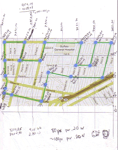
Paul's Savable Google MapsSo I decided to design up the google map capture program while I was at it. This is the new interface found at

Here is the largest map I have downloaded so far. It is most of Western New York at 2560 pixels by 2560 pixels big. I want to get all of america. I was thinking it would be really easy to systematically download every tile from google maps so that you could have them for the future if something ever happend to google.

This reminds me of that one time I downloaded 80,000 corporate logos in vector format. I never did anything with them yet, but it was fun collecting.
Here is the largest map I have downloaded so far. It is most of Western New York at 2560 pixels by 2560 pixels big. I want to get all of america. I was thinking it would be really easy to systematically download every tile from google maps so that you could have them for the future if something ever happend to google.
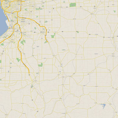
This reminds me of that one time I downloaded 80,000 corporate logos in vector format. I never did anything with them yet, but it was fun collecting.
04/19/2005 03:06 #31857
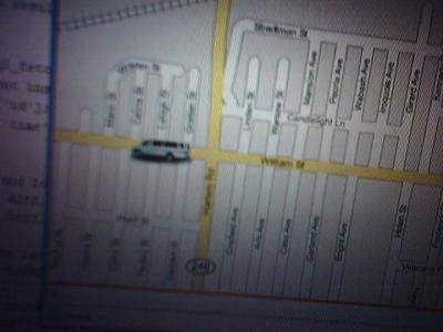
Public Transphere New LookYou can visit the new version here. Don't forget to stop out on saturday or sunday for the big event.

Well, it all started out when I saw (e:ajay) 's site about google and I just couldn't stop after that. The softwar n ow let's you pick an arbitrary google map at zoom 2 and then works. I have to say he is all around inspirational because he is also the guy that got me hooked on xmlHTTP. I remember when I was visiting him for some linux help one day and he mentioned it. I sersiously had no idea how great it was. Soon enough I will totally redo this site to be way cooler. With networked live user interaction.

How does it work?
Basically, a cell-phone sends data from a GPS in the moving vehicle to a MySQL database. A PHP file reads from that database and makes it available to the world. The same PHP file, disguised as a tiny xml file calculates the current latitude and longitude in pixel location values. The xml file is then read into the browser DOM using xmlHTTP, a javascript technology. With the live location data, the van icon is moved on the map accordingly via javascript. The site continues to poll the database every 5 seconds for smooth real-time mapping yet maintains very low bandwidth data requirements as the page never has to reload.
The site is also capable of extreme error handling so that the end user does not notice an glitches with missing or innacurate data. The site even has a debug mode, that is avaiable by hitting the "d" key on the keyboard. Furthermore, the user can surf the history of the van's movement by using the left and right arrow keys.
There is are also some shortcuts.
Left and right arrow - go back in time and return to the present time
T = tracking mode
D = debug mode
s = satellite image
r = show and hide route
Well, it all started out when I saw (e:ajay) 's site about google and I just couldn't stop after that. The softwar n ow let's you pick an arbitrary google map at zoom 2 and then works. I have to say he is all around inspirational because he is also the guy that got me hooked on xmlHTTP. I remember when I was visiting him for some linux help one day and he mentioned it. I sersiously had no idea how great it was. Soon enough I will totally redo this site to be way cooler. With networked live user interaction.
How does it work?
Basically, a cell-phone sends data from a GPS in the moving vehicle to a MySQL database. A PHP file reads from that database and makes it available to the world. The same PHP file, disguised as a tiny xml file calculates the current latitude and longitude in pixel location values. The xml file is then read into the browser DOM using xmlHTTP, a javascript technology. With the live location data, the van icon is moved on the map accordingly via javascript. The site continues to poll the database every 5 seconds for smooth real-time mapping yet maintains very low bandwidth data requirements as the page never has to reload.
The site is also capable of extreme error handling so that the end user does not notice an glitches with missing or innacurate data. The site even has a debug mode, that is avaiable by hitting the "d" key on the keyboard. Furthermore, the user can surf the history of the van's movement by using the left and right arrow keys.
There is are also some shortcuts.
Left and right arrow - go back in time and return to the present time
T = tracking mode
D = debug mode
s = satellite image
r = show and hide route
